
During the very close opposition of 1988 I was a geography major in college so I was into maps and such. Back then I set out to actually compile a couple of maps based on sketches done at the eyepiece of the 3" apo I had at the time.
The top map is made from the first 6 to 10 sketches I made, fairly early on in the apparition when relatively little detail was visible.
The second map was compiled from sketches done near peak opposition in 1988, again mostly with a 3" apo, with a few 'booster' sketches from an old 8" SCT. Note how canals disappeared and features were much more distinct.
The bottom sketch is compiled from the 31 finished sketches I've done so far with my 10" f/8, along with a tiny bit from two working sketches done just tonight.
I am here following the geographic convention of north at top, with proper left-right orientation, just so no one accuses me of being a newtonian chauvinist or anything.
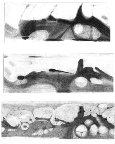
The top map is made from the first 6 to 10 sketches I made, fairly early on in the apparition when relatively little detail was visible.
The second map was compiled from sketches done near peak opposition in 1988, again mostly with a 3" apo, with a few 'booster' sketches from an old 8" SCT. Note how canals disappeared and features were much more distinct.
The bottom sketch is compiled from the 31 finished sketches I've done so far with my 10" f/8, along with a tiny bit from two working sketches done just tonight.
I am here following the geographic convention of north at top, with proper left-right orientation, just so no one accuses me of being a newtonian chauvinist or anything.
Attached Image: