Image of the day

Captured by
Lawrence Parchman

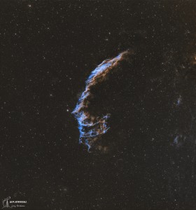
Eastern Veil Nebula (NGC 6992) - Wide View

My Account

New to Astromart?

Register an account...

Need Help?

Virgo Occultations - Dec 23 & 25

Started by curtrenz, 12/09/2005 03:04AM
Posted 12/09/2005 03:04AM | Edited 12/09/2005 05:38AM Opening Post
Get that new Christmas telescope unwrapped early. Spica, the 1.0 magnitude star in Virgo, will be occulted by the Moon for North Americans on Christmas morning. Mag 3.6 Beta Virginis will be occulted for North Americans two days earlier. That event will occur during the wee hours of the night. The Spica occultation will occur at nighttime for those in the west, but will be a daytime event for easterners. Yes, the star can be seen in daylight with optical aid.

I’ve prepared graphics and data for both occultations as seen from Chicago’s Adler Planetarium. To see them, click:
http://www.curtrenz.com/astronomical.html

Spica: RA 13:25.5 - Decl S 11°12'
Beta Virginis: RA 11:51.0 - Decl N 1°44'

If you will reply to this thread with your specific coordinates (Longitude, Latitude, Time Zone and approximate Altitude above sea level), I will provide you with customized occultation data.

The graphics may be removed soon after each event occurs. Merry Christmas! grin

For astronomical graphics, including
monthly wallpaper calendar, visit:
CurtRenz.com/astronomical

Curt Renz
Posted 12/16/2005 12:12AM | Edited 12/19/2005 08:02PM #1
The southern graze path for the occultation of Mag 3.6 Beta Virginis during the early morning hours of 2005 DEC 23 will cross the USA from California to Florida. The northern graze path will run across arctic Canada. Those between the graze paths will witness a full occultation. Those on the graze path will be able to see the star winking on and off as lunar hills and valleys pass by. Finding an observation spot right on the graze line is always a challenge for an astronomical enthusiast.

The apparent disk of the waning Moon will be 54% illuminated. Those seeing a full occultation will watch the bright limb of the Moon cover the star; later the star will emerge from the dark limb. The star’s celestial coordinates of date will be RA 11:51.0 and Dec N 1°44’. smile

To see the map I plotted for the graze path, click: http://www.curtrenz.com/astronomical.html . The pink portion of the path indicates a daylight event. The numerals represent the Universal Time.

Below are my calculated geographic coordinates for the points on the graze path separated by five degrees of longitude. The times are UT. ZA is the Zenith Angle, which is the position of the star on the lunar limb as measured counter-clockwise from the zenith. Sea level is assumed due to the variance in altitude between plotted points. Linear interpolation would be insufficient for intermediate longitudes, but quadratic interpolation should get you close. However, please feel free to reply within this thread to learn the data that go with any specific longitudes and altitudes (above sea level) you provide.

08:11:02 UT - ZA 260.3°
W 125° – N 37.85215°
Pacific Ocean, 231 kilometers west of San Francisco, CA

08:12:13 UT - ZA 261.3°
W 120° – N 37.80308°
Stanislaus National Forest, 3 km SE of Colfax Spring, CA

08:14:06 UT - ZA 262.2°
W 115° – N 37.56101°
Nevada, 6 kilometers south of Pahroc Summit Pass

08:16:46 UT - ZA 263.2°
W 110° – N 37.10504°
Navajo Indian Reservation, 13 km SW of Mexican Hat, UT

08:20:21 UT - ZA 264.3°
W 105° – N 36.40849°
Elliot Barker State Wildlife Area, 8 km NW of Rayado, NM

08:24:58 UT - ZA 265.4°
W 100° – N 35.43664°
TX/OK state line 4 kilometers southwest of Meridian, OK

08:30:52 UT - ZA 266.4°
W 95° – N 34.14360°
7 kilometers southeast of Alikchi, OK

08:38:19 UT - ZA 267.4°
W 90° – N 32.46768°
Ross Barnett Reservoir, 26 km NE of downtown Jackson, MS

08:47:41 UT - ZA 268.1°
W 85° – N 30.32535°
4 kilometers northeast of Estiffanulga, FL

08:59:29 UT - ZA 268.2°
W 80° – N 27.60432°
Atlantic Ocean, 18 kilometers east of Route 1, Oslo, FL

For astronomical graphics, including
monthly wallpaper calendar, visit:
CurtRenz.com/astronomical

Curt Renz

Posted 12/19/2005 08:01PM | Edited 12/19/2005 08:11PM #2
The southern graze path for the occultation of Mag 1.0 Spica in Virgo during the morning of 2005 DEC 25 will cross the western USA from Alaska to Texas and into Mexico. There will be no northern graze path. For westerners the occultation will occur during nighttime. In the east the Sun will have risen, but the star should be visible in a telescope.

Those north and east of the graze path will witness a full occultation. Those on the graze path will be able to see the star winking on and off as lunar hills and valleys pass by. Finding an observation spot right on the graze line is always a challenge for an astronomical enthusiast.

The apparent disk of the waning Moon will be 33% illuminated. Those seeing a full occultation will watch the bright limb of the Moon cover the star; later the star will emerge from the dark limb. The star’s celestial coordinates of date will be RA 13:25.5 and Dec S 11°12’. smile

To see the map I plotted for the graze path, click: http://www.curtrenz.com/astronomical.html . The pink portion of the path indicates a daylight event. The numerals represent the Universal Time.

Below are my calculated geographic coordinates for the points on the graze path separated by five degrees of longitude. The times are UT. ZA is the Zenith Angle, which is the position of the star on the lunar limb as measured counter-clockwise from the zenith. Sea level is assumed due to the variance in altitude between plotted points. Linear interpolation would be insufficient for intermediate longitudes, but quadratic interpolation should get you close. However, please feel free to reply within this thread to learn the data that go with any specific longitudes and altitudes (above sea level) you provide.

13:29:57 UT - ZA 239.0°
W 125° – N 48.12053°
Pacific Ocean, 22 kilometers west of Ozette, WA

13:37:00 UT - ZA 237.7°
W 120° – N 44.71127°
4 kilometers southeast of Waldron, OR

13:46:22 UT - ZA 234.9°
W 115° – N 40.72973°
5 kilometers southeast of Clover, NV

13:58:37 UT - ZA 229.7°
W 110° – N 36.13305°
Navajo Indian Reservation, 6 km SW of Blue Gap, AZ

14:13:58 UT - ZA 220.6°
W 105° – N 30.99516°
16 kilometers west of Van Horn, TX

14:31:43 UT - ZA 206.4°
W 100° – N 25.62933°
5 kilometers north of Cadereyta Jimenez, Mexico

For astronomical graphics, including
monthly wallpaper calendar, visit:
CurtRenz.com/astronomical

Curt Renz